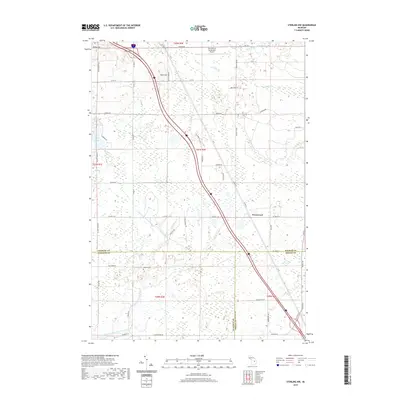
2019 Map of Sterling NW
USGS Topo · Published 2019About this map
Greenwood sits at the junction of several county routes in this 2019 survey, which covers a rural landscape defined by the drainage systems of two distinct rivers. The northern section is dominated by the West Branch Rifle River and the undulating terrain of the Cook Hills and Tolfee Hill. To the south, the geography shifts toward the headwaters and tributaries of the East Branch Tittabawassee River, including Spring Cr and Lafave Cr. This modern map documents the rural infrastructure of Ogemaw and Gladwin counties, showing the proximity of the West Branch Community Airport to the agricultural and wooded lands that characterize the region. Genealogists may find interest in the Bourret Cem located near the border of Gladwin and Arenac counties. The map also traces contemporary recreational and access paths, such as the Dog Sled Trl and Loggers Trl, illustrating the area's ongoing connection to its forested environment.
Find a feature on this map
62 named features on this map. Tap any name to fly to it.
Don’t see what you’re looking for? This feature index may not catch every label — zoom into the map to look around manually.
Map Details
Editions of this 2019 Sterling NW Map
This is the sole edition of this map. No revisions or reprints were ever made.
Other maps of this area

1954 · Traverse City
USGS Topo · 1:250,000

1958 · Traverse City
USGS Topo · 1:250,000

1965 · West Branch
USGS Topo · 1:24,000

1965 · Ogemaw Springs
USGS Topo · 1:24,000

1965 · Selkirk
USGS Topo · 1:24,000

1968 · Sterling
USGS Topo · 1:24,000
1968 · Skidway Lake
USGS Topo · 1:24,000

1968 · Sterling SW
USGS Topo · 1:24,000

1968 · Sterling NW
USGS Topo · 1:24,000

1969 · Edwards
USGS Topo · 1:24,000