
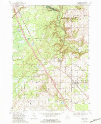
1968 Map of Sterling
USGS Topo · Published 1971About this map
The Penn Central railroad corridor anchors the landscape of this Arenac County region, connecting the rural communities of Alger and Sterling. This late-1960s survey documents a transition between organized agriculture and extractive industry, highlighted by the Deep River Gas and Oil Field east of Sterling. Extensive wooded tracts and wetlands characterize the Tittabawassee River State Forest, where the Tittabawassee River and Rifle River snake through the terrain. Local history is preserved in the placement of the Alger Cem and St George Cem, while small settlements like Melita and Adams appear alongside a network of country roads such as Townline Road and Ellison Road. The map also captures specific industrial details including scattered Oil Wells and numerous Gravel Pits that supported the local infrastructure.
Find a feature on this map
43 named features on this map. Tap any name to fly to it.
Don’t see what you’re looking for? This feature index may not catch every label — zoom into the map to look around manually.
Map Details
Editions of this 1968 Sterling Map
2 editions found
Other maps of this area

1954 · Traverse City
USGS Topo · 1:250,000

1954 · Midland
USGS Topo · 1:250,000

1954 · Flint
USGS Topo · 1:250,000

1954 · Tawas City
USGS Topo · 1:250,000

1958 · Traverse City
USGS Topo · 1:250,000

1958 · Flint
USGS Topo · 1:250,000

1958 · Tawas City
USGS Topo · 1:250,000

1958 · Midland
USGS Topo · 1:250,000

1959 · Midland
USGS Topo · 1:250,000

1966 · Midland
USGS Topo · 1:250,000