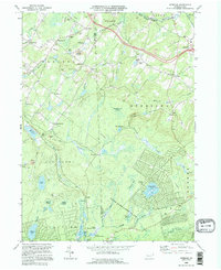
1994 Map of Sterling
USGS Topo · Published 1995About this map
The Lackawanna and Wayne County border defines this stretch of the Poconos, where the rugged terrain of the State Game Lands No 312 meets growing residential developments. In the mid-1990s, the landscape was a mix of traditional crossroads settlements and newer recreational enclaves. The northern portion features the established villages of Sterling and Madisonville, while the southeastern corner is dominated by the sprawling community of Pocono Springs surrounding Pocono Peak Lake.
Find a feature on this map
71 named features on this map. Tap any name to fly to it.
Don’t see what you’re looking for? This feature index may not catch every label — zoom into the map to look around manually.
Map Details
Editions of this 1994 Sterling Map
This is the sole edition of this map. No revisions or reprints were ever made.
Other maps of this area

1889 · Scranton
USGS Topo · 1:62,500

1891 · Scranton
USGS Topo · 1:62,500

1893 · Scranton
USGS Topo · 1:62,500

1919 · Pocono
USGS Topo · 1:62,500

1921 · Pocono
USGS Topo · 1:62,500

1922 · Stoddartsville
USGS Topo · 1:62,500

1923 · Pocono
USGS Topo · 1:62,500

1924 · Stoddartsville
USGS Topo · 1:62,500

1928 · Ariel
USGS Topo · 1:62,500

1932 · Ariel
USGS Topo · 1:62,500
Featured Places
- Sterling Township, PA
- Clifton Township, PA
- Madisonville, Madison Township
- Dreher Township, PA
- Lehigh Township, PA