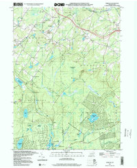
1997 Map of Sterling
USGS Topo · Published 2000About this map
Madisonville and the surrounding highlands of the Madison and Sterling townships define this landscape in the late 1990s. The region is characterized by a high concentration of water bodies and wetlands, including Thousand Acre Swamp and Wildcat Swamp, which feed the headwaters of several significant drainage systems. The West Branch Wallenpaupack Creek and the West Fork Lehigh River both originate in these uplands, illustrating the area's role as a local watershed divide.
Find a feature on this map
52 named features on this map. Tap any name to fly to it.
Don’t see what you’re looking for? This feature index may not catch every label — zoom into the map to look around manually.
Map Details
Editions of this 1997 Sterling Map
This is the sole edition of this map. No revisions or reprints were ever made.
Other maps of this area

1889 · Scranton
USGS Topo · 1:62,500

1891 · Scranton
USGS Topo · 1:62,500

1893 · Scranton
USGS Topo · 1:62,500

1919 · Pocono
USGS Topo · 1:62,500

1921 · Pocono
USGS Topo · 1:62,500

1922 · Stoddartsville
USGS Topo · 1:62,500

1923 · Pocono
USGS Topo · 1:62,500

1924 · Stoddartsville
USGS Topo · 1:62,500

1928 · Ariel
USGS Topo · 1:62,500

1932 · Ariel
USGS Topo · 1:62,500
Featured Places
- Sterling Township, PA
- Clifton Township, PA
- Madisonville, Madison Township
- Dreher Township, PA
- Lehigh Township, PA