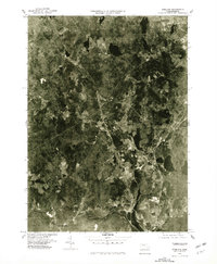
1975 Map of Sterling
USGS Topo · Published 1981About this map
Sterling and its surrounding hamlets are captured in this mid-1970s orthophotomap, showing the transition from the dense industrial edges of Leominster to the rural expanses of Worcester County. The landscape is defined by the critical watershed of the Wachusett Reservoir, where the Stillwater River and Quinapoxet River converge at Oakdale. This aerial perspective reveals the 1970s land use patterns, contrasting the clustered village centers of East Princeton and West Sterling against a backdrop of evolving woodlots and agricultural fields. By utilizing rectified aerial photography, this survey provides a precise look at the road networks and property clearings near Moores Corner before later suburban development altered the character of these central Massachusetts towns.
Find a feature on this map
9 named features on this map. Tap any name to fly to it.
Don’t see what you’re looking for? This feature index may not catch every label — zoom into the map to look around manually.
Map Details
Editions of this 1975 Sterling Map
This is the sole edition of this map. No revisions or reprints were ever made.
Other maps of this area

1885 · Worcester
USGS Topo · 1:62,500

1886 · Worcester
USGS Topo · 1:62,500

1887 · Marlboro
USGS Topo · 1:62,500

1887 · Fitchburg
USGS Topo · 1:62,500

1889 · Marlboro
USGS Topo · 1:62,500

1889 · Fitchburg
USGS Topo · 1:62,500

1892 · Worcester
USGS Topo · 1:62,500

1893 · Fitchburg
USGS Topo · 1:62,500

1893 · Groton
USGS Topo · 1:62,500

1896 · Marlboro
USGS Topo · 1:62,500