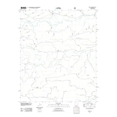
2011 Map of Steve
USGS Topo · Published 2011About this map
Steve serves as the central settlement in this portion of Yell County, situated north of the meandering South Fourche LaFave River. The geography is defined by a dense network of watercourses, including Graham Creek, Seaton Creek, and Bear Creek, which drain the varied elevations of Dry Fork Mountain and Powell Mountain. This 2011 survey reveals a landscape of forestry and rural transit, where named routes like Powell Mountain Rd and Gladstone Forest Rd weave through the timberlands.
Find a feature on this map
42 named features on this map. Tap any name to fly to it.
Don’t see what you’re looking for? This feature index may not catch every label — zoom into the map to look around manually.
Map Details
Editions of this 2011 Steve Map
This is the sole edition of this map. No revisions or reprints were ever made.
Other maps of this area

1890 · Hot Springs
USGS Topo · 1:125,000

1894 · Hot Springs
USGS Topo · 1:125,000

1955 · Little Rock
USGS Topo · 1:250,000

1956 · Little Rock
USGS Topo · 1:250,000

1960 · Little Rock
USGS Topo · 1:250,000

1962 · Avant
USGS Topo · 1:24,000

1962 · Fannie
USGS Topo · 1:24,000

1964 · Little Rock
USGS Topo · 1:250,000
1968 · Plainview
USGS Topo · 1:24,000
1968 · Onyx
USGS Topo · 1:24,000