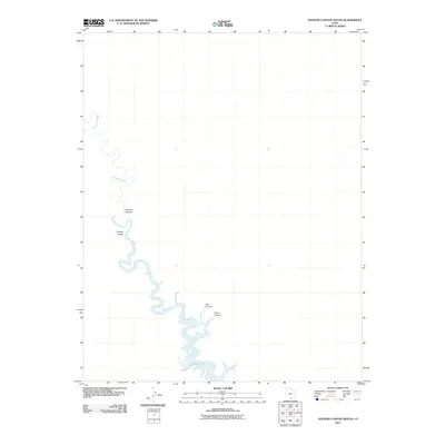
2011 Map of Stevens Canyon South
USGS Topo · Published 2011About this map
The Escalante River winds through this high desert landscape, carving deep meanders before reaching the northern reaches of Lake Powell. This 2011 survey illustrates the dramatic intersection where river-cut canyons meet the backwaters of the reservoir. Several prominent drainage systems, including Coyote Gulch and Stevens Canyon, define the western side of the river's path. Further south, the map identifies Cow Canyon and Fence Canyon, providing a clear view of the complex topography leading toward the open waters. The imagery and data, sourced from 2009 records, document the shoreline and water levels of the period, reflecting the environmental conditions of the early twenty-first century in this unpopulated stretch of southern Utah.
Find a feature on this map
6 named features on this map. Tap any name to fly to it.
Don’t see what you’re looking for? This feature index may not catch every label — zoom into the map to look around manually.
Map Details
Editions of this 2011 Stevens Canyon South Map
This is the sole edition of this map. No revisions or reprints were ever made.
Other maps of this area

1886 · Escalante
USGS Topo · 1:250,000

1886 · Henry Mountains
USGS Topo · 1:250,000

1892 · Henry Mountains
USGS Topo · 1:250,000

1953 · Mt Pennell 3 SW
USGS Topo · 1:24,000

1953 · The Rincon
USGS Topo · 1:62,500

1953 · Hall Mesa
USGS Topo · 1:62,500

1953 · Moody Creek
USGS Topo · 1:62,500

1956 · Escalante
USGS Topo · 1:250,000

1960 · Escalante
USGS Topo · 1:250,000
1968 · Sooner Bench
USGS Topo · 1:24,000