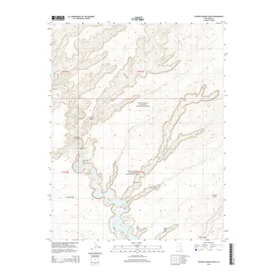
2014 Map of Stevens Canyon South
USGS Topo · Published 2014About this map
The Escalante River carves through the sandstone plateaus of Kane County, feeding into the northern reaches of Lake Powell within the Glen Canyon National Recreation Area. This desert landscape is defined by its dramatic verticality, where the high plateau of Fortymile Ridge drops away into a complex system of tributary drainages. Natural landmarks like the massive Stevens Arch and the more isolated Zane Grey Arch serve as distinct navigational points for those traversing the canyon floor. The map documents the intricate junction where Coyote Gulch and Stevens Canyon meet the river, a traditional corridor for movement through the backcountry. Significant side drainages including Cow Canyon, Fence Canyon, and Explorer Canyon illustrate the erosional patterns that have shaped this portion of the Colorado River basin.
Find a feature on this map
16 named features on this map. Tap any name to fly to it.
Don’t see what you’re looking for? This feature index may not catch every label — zoom into the map to look around manually.
Map Details
Editions of this 2014 Stevens Canyon South Map
This is the sole edition of this map. No revisions or reprints were ever made.
Other maps of this area

1886 · Escalante
USGS Topo · 1:250,000

1886 · Henry Mountains
USGS Topo · 1:250,000

1892 · Henry Mountains
USGS Topo · 1:250,000

1953 · Mt Pennell 3 SW
USGS Topo · 1:24,000

1953 · The Rincon
USGS Topo · 1:62,500

1953 · Hall Mesa
USGS Topo · 1:62,500

1953 · Moody Creek
USGS Topo · 1:62,500

1956 · Escalante
USGS Topo · 1:250,000

1960 · Escalante
USGS Topo · 1:250,000
1968 · Sooner Bench
USGS Topo · 1:24,000