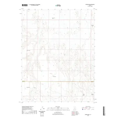
2020 Map of Stevens Mesa
USGS Topo · Published 2020About this map
The Wayne and Garfield County line bisects this remote high-desert landscape, dominated by the uplifted profiles of Stevens Mesa and Thompson Mesa. The terrain is defined by the erosion patterns of the Henry Mountains to the southeast, where seasonal drainages like Sweetwater Creek and Cedar Creek have carved deep into the plateau. This 2020 survey documents critical water sources in an otherwise arid environment, including the Indianwater Seep and Maidenwater Spring. North of the county boundary, the Upper Blue Hills and Oak Creek Ridge show the transition toward more complex geological formations. This data reveals a landscape where topographic relief dictates the limited accessibility, with names like Wildcat Mesa and Dry Wash suggesting the character of the ground before modern infrastructure arrived.
Find a feature on this map
15 named features on this map. Tap any name to fly to it.
Don’t see what you’re looking for? This feature index may not catch every label — zoom into the map to look around manually.
Map Details
Editions of this 2020 Stevens Mesa Map
This is the sole edition of this map. No revisions or reprints were ever made.
Other maps of this area

1885 · San Rafael
USGS Topo · 1:250,000

1885 · Fish Lake
USGS Topo · 1:250,000

1896 · Fish Lake
USGS Topo · 1:250,000

1952 · Notom 4 SE
USGS Topo · 1:24,000

1952 · Notom 4 NE
USGS Topo · 1:24,000

1952 · Notom
USGS Topo · 1:62,500

1954 · Mt. Ellen 2 SE
USGS Topo · 1:24,000

1954 · Mt. Ellen 2 SW
USGS Topo · 1:24,000

1954 · Fruita
USGS Topo · 1:62,500
1954 · Notom 1 SE
USGS Topo · 1:24,000