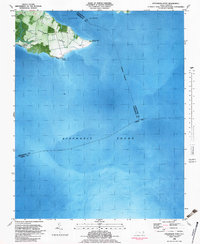
1982 Map of Stevenson Point
USGS Topo · Published 1983About this map
Durants Neck extends into the expansive waters of the Albemarle Sound and the Little River, showcasing the coastal geography of Perquimans County in the early 1980s. This orthophotomap combines traditional topographic data with aerial imagery, revealing the distinct boundaries between land and water along this maritime peninsula. Small coastal settlements such as Carolina Shores and Leighs Temple occupy the northwestern corner of the neck, while the shoreline is protected in places by a Seawall near Reed Point. A maritime Light sits offshore in the sound, marking the navigational hazards where the county lines of Pasquotank, Perquimans, and Tyrrell converge in open water. The map's detail provides a clear view of the land-use patterns on the peninsula, contrasting wooded areas and open fields with the surrounding aquatic environment.
Find a feature on this map
13 named features on this map. Tap any name to fly to it.
Don’t see what you’re looking for? This feature index may not catch every label — zoom into the map to look around manually.
Map Details
Editions of this 1982 Stevenson Point Map
This is the sole edition of this map. No revisions or reprints were ever made.
Other maps of this area

1906 · Hertford
USGS Topo · 1:62,500

1940 · Hertford
USGS Topo · 1:62,500

1940 · Wade Point
USGS Topo · 1:62,500

1943 · Wade Point
USGS Topo · 1:62,500

1943 · Columbia
USGS Topo · 1:125,000

1948 · Wade Point
USGS Topo · 1:62,500

1953 · Norfolk
USGS Topo · 1:250,000

1953 · Columbia East
USGS Topo · 1:24,000

1953 · Columbia West
USGS Topo · 1:24,000
1953 · Fort Landing
USGS Topo · 1:24,000