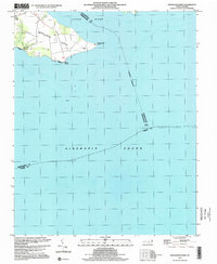
1997 Map of Stevenson Point
USGS Topo · Published 2000About this map
Durants Neck dominates this coastal survey, reaching south into the wide waters of the Albemarle Sound. This peninsula is a landscape defined by its relation to the water, bordered on the north by the Little River and marked by distinct landform extremities like Stevenson Point and Reed Point. The small settlement of Leighs Temple sits at the northern edge of the neck, while the development at Carolina Shores represents the modern residential footprint along the western shore. A prominent Seawall runs along the southern tip of the neck, indicating active coastal management where the land meets the sound. Farther out in the water, a solitary Light serves as a navigational marker for those traversing the sound, while the county boundaries between Pasquotank, Perquimans, and Tyrrell intersect in the open water.
Find a feature on this map
13 named features on this map. Tap any name to fly to it.
Don’t see what you’re looking for? This feature index may not catch every label — zoom into the map to look around manually.
Map Details
Editions of this 1997 Stevenson Point Map
This is the sole edition of this map. No revisions or reprints were ever made.
Other maps of this area

1906 · Hertford
USGS Topo · 1:62,500

1940 · Hertford
USGS Topo · 1:62,500

1940 · Wade Point
USGS Topo · 1:62,500

1943 · Wade Point
USGS Topo · 1:62,500

1943 · Columbia
USGS Topo · 1:125,000

1948 · Wade Point
USGS Topo · 1:62,500

1953 · Norfolk
USGS Topo · 1:250,000

1953 · Columbia East
USGS Topo · 1:24,000

1953 · Columbia West
USGS Topo · 1:24,000
1953 · Fort Landing
USGS Topo · 1:24,000