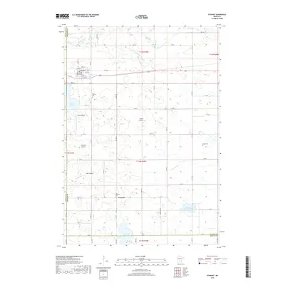
2019 Map of Stewart
USGS Topo · Published 2019About this map
Stewart serves as the primary hub in this agricultural landscape of McLeod County, where a grid of rural roads and county highways connects small settlements and historical sites. The terrain is defined by its transition from active waterways like Buffalo Cr and High Island Cr to numerous dry lakebeds, including Halls Lakebed, Nutter Lakebed, and Showburg Lakebed. These features point to a shifting hydrological environment where early drainage efforts, such as Judicial Ditch Number Twentyfour and County Ditch Number Sixtyfour, transformed the prairie into productive farmland. For genealogists, the map preserves the exact locations of local burial grounds such as Round Grove Cem, Saint Boniface Cem, and Draeger Cem, while the small community of Fernando stands as a distinct locality near the southern border of the township.
Find a feature on this map
66 named features on this map. Tap any name to fly to it.
Don’t see what you’re looking for? This feature index may not catch every label — zoom into the map to look around manually.
Map Details
Editions of this 2019 Stewart Map
This is the sole edition of this map. No revisions or reprints were ever made.
Other maps of this area

1953 · New Ulm
USGS Topo · 1:250,000

1957 · New Ulm
USGS Topo · 1:250,000

1958 · New Ulm
USGS Topo · 1:250,000

1958 · Winthrop
USGS Topo · 1:62,500

1958 · Hutchinson
USGS Topo · 1:62,500

1964 · Buffalo Lake
USGS Topo · 1:24,000

1964 · Gibbon
USGS Topo · 1:24,000

1967 · New Ulm
USGS Topo · 1:250,000
1967 · Lake Allie
USGS Topo · 1:24,000
1982 · Heatwole
USGS Topo · 1:24,000