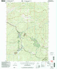
2004 Map of Stibnite
USGS Topo · Published 2007About this map
The Yellow Pine Mine and its extensive Tailings fields dominate the upper drainage of the East Fork South Fork Salmon River, reflecting the heavy industrial legacy of this Idaho interior. This 2004 revision documents the landscape's transition from active extraction to historical preservation, marking significant locations like Stibnite (Hist Site) and Monday Camp (Hist Site). The topography is defined by the sharp transition from the managed lands of the Payette National Forest to the protected wilderness of the Frank Church - River of No Return Wilderness. Transportation into this challenging terrain follows the Stibnite Road and Thunder Mountain Road, which link the various extraction points such as the Fern Mine and the remote Meadow Creek Landing Field. These routes and historical sites provide a record of the early 21st-century state of a region defined by its minerals and its isolation.
Find a feature on this map
40 named features on this map. Tap any name to fly to it.
Don’t see what you’re looking for? This feature index may not catch every label — zoom into the map to look around manually.
Map Details
Editions of this 2004 Stibnite Map
This is the sole edition of this map. No revisions or reprints were ever made.
Other maps of this area

1937 · Yellow Pine
USGS Topo · 1:48,000

1937 · Big Creek
USGS Topo · 1:48,000

1942 · Big Creek
USGS Topo · 1:62,500

1943 · Yellow Pine
USGS Topo · 1:62,500

1956 · Elk City
USGS Topo · 1:250,000

1957 · Challis
USGS Topo · 1:250,000

1960 · Elk City
USGS Topo · 1:250,000

1960 · Challis
USGS Topo · 1:250,000

1963 · Challis
USGS Topo · 1:250,000

1969 · Edwardsburg
USGS Topo · 1:24,000