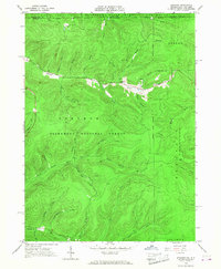
1966 Map of Stickney
USGS Topo · Published 1968About this map
Stickney serves as the central focal point of this mid-1960s survey, situated along the meandering course of Willow Creek where it meets Cobb Creek. This area of the Pennsylvania-New York border is defined by a dense network of steep drainages and logging or maintenance access routes like Boatroad and Harlow Trail. The landscape reveals a legacy of resource extraction, with numerous Oil Wells scattered through the valleys of Porter Hollow and Cobb Hollow. Much of the terrain falls within the Allegheny National Forest, transitioning northward across the state line into Allegany State Park and the Red House area. The topographic detail captures a rugged geography of family-named hollows, including Schoolhouse Hollow and Holmes Hollow, suggesting the location of early rural infrastructure and homesteads that predated the consolidation of the forest lands.
Find a feature on this map
41 named features on this map. Tap any name to fly to it.
Don’t see what you’re looking for? This feature index may not catch every label — zoom into the map to look around manually.
Map Details
Editions of this 1966 Stickney Map
3 editions found
Other maps of this area

1900 · Salamanca
USGS Topo · 1:62,500

1922 · Randolph
USGS Topo · 1:62,500

1923 · Randolph
USGS Topo · 1:62,500

1924 · Bradford
USGS Topo · 1:62,500

1926 · Bradford
USGS Topo · 1:62,500

1936 · Kinzua
USGS Topo · 1:48,000

1938 · Salamanca
USGS Topo · 1:62,500

1941 · Kinzua
USGS Topo · 1:62,500

1941 · Bradford
USGS Topo · 1:62,500

1943 · Randolph
USGS Topo · 1:62,500