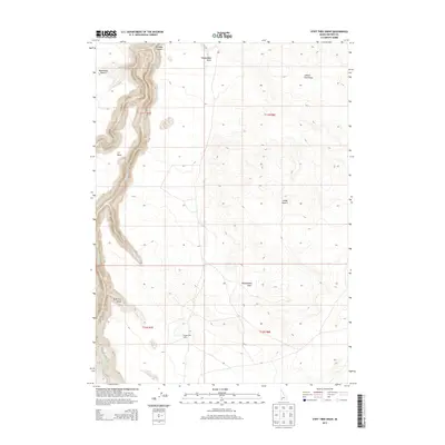
2013 Map of Stiff Tree Draw
USGS Topo · Published 2013About this map
Bruneau Canyon dominates this high desert landscape, carved deeply into the Owyhee plateau by the Bruneau River. The dramatic elevation drop from the surrounding plains into the canyon floor creates a stark contrast with the arid flats of the Blackstone Desert and Inside Desert. This survey captures the region's ranching legacy and remote character, as evidenced by isolated landmarks like the Bengoechea Cabin. Extensive drainage systems such as Sheepshead Draw, Juniper Tree Draw, and the namesake Stiff Tree Draw illustrate the complex hydraulic patterns that feed the main river system. Notable geographic markers like J-P Point and Sheep Cr provide critical orientation points in this expanse of southern Idaho.
Find a feature on this map
14 named features on this map. Tap any name to fly to it.
Don’t see what you’re looking for? This feature index may not catch every label — zoom into the map to look around manually.
Map Details
Editions of this 2013 Stiff Tree Draw Map
This is the sole edition of this map. No revisions or reprints were ever made.
Other maps of this area

1955 · Twin Falls
USGS Topo · 1:250,000

1956 · Blue Butte
USGS Topo · 1:62,500

1956 · Winter Camp
USGS Topo · 1:62,500

1958 · Twin Falls
USGS Topo · 1:250,000

1979 · Stiff Tree Draw
USGS Topo · 1:24,000

1979 · Indian Hot Springs
USGS Topo · 1:24,000

1979 · Clover Butte South
USGS Topo · 1:24,000

1979 · Cave Draw
USGS Topo · 1:24,000
1979 · Inside Lakes
USGS Topo · 1:24,000
1980 · Austin Butte
USGS Topo · 1:24,000