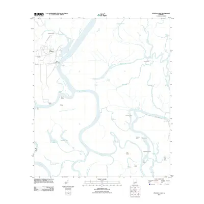
2011 Map of Stiggins Lake
USGS Topo · Published 2011About this map
Fort Stoddard and its historical counterpart, Old Fort Stoddard Mount Vernon Landing, anchor this river-dominated landscape at the confluence of human history and the Alabama delta. Situated along the west bank of the Mobile River, the map documents a complex web of waterways including the Tensaw River and Middle River, punctuated by numerous named islands like Richardson Island and Canal Island. The land use reflects a mix of heritage and industry, evidenced by the Morningstar Cemetery and the presence of the Movico Oil Field.
Find a feature on this map
49 named features on this map. Tap any name to fly to it.
Don’t see what you’re looking for? This feature index may not catch every label — zoom into the map to look around manually.
Map Details
Editions of this 2011 Stiggins Lake Map
This is the sole edition of this map. No revisions or reprints were ever made.
Other maps of this area

1941 · Bay Minette
USGS Topo · 1:62,500

1941 · Creola
USGS Topo · 1:62,500

1943 · Creola
USGS Topo · 1:62,500

1943 · Bay Minette
USGS Topo · 1:62,500

1943 · Tensaw
USGS Topo · 1:62,500

1943 · Citronelle
USGS Topo · 1:62,500

1944 · Tensaw
USGS Topo · 1:62,500

1946 · Citronelle
USGS Topo · 1:62,500

1953 · Andalusia
USGS Topo · 1:250,000

1953 · Hattiesburg
USGS Topo · 1:250,000