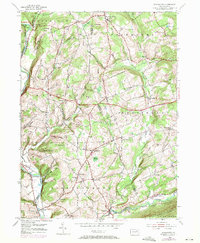
1954 Map of Stillwater
USGS Topo · Published 1971About this map
Fishing Creek and its many tributaries, including Coles Creek and Raven Creek, carve a complex landscape of ridges and hollows across the Columbia Co and Luzerne Co border. This mid-century view reveals a rural network of small hamlets and farmsteads connected by winding roads and a prominent Pipeline. The map captures several crossroads communities such as New Columbus, Fairmount Springs, and Stillwater at a time when local institutions remained central to rural life. Local genealogy and history are well-represented by a high density of small family or community burial grounds, including Boston Cem, Thompson Cem, and Dodson Cem. Notable landmarks such as St James Ch and the Zaner Sch reflect the social fabric of the valley, while industrial activities are marked by several Quarries and a Sand Pit near Fairmount Springs. The presence of the Boy Scout Camp Swimming Pool near the northern edge suggests the area's role as a recreational retreat amidst the terrain of Sugarloaf and Hess Hill.
Find a feature on this map
60 named features on this map. Tap any name to fly to it.
Don’t see what you’re looking for? This feature index may not catch every label — zoom into the map to look around manually.
Map Details
Editions of this 1954 Stillwater Map
4 editions found
Other maps of this area

1891 · Harveys Lake
USGS Topo · 1:62,500

1893 · Harvey Lake
USGS Topo · 1:62,500

1894 · Shickshinny
USGS Topo · 1:62,500

1894 · Bloomsburg
USGS Topo · 1:62,500

1934 · Laporte
USGS Topo · 1:62,500

1946 · Shickshinny
USGS Topo · 1:31,680

1946 · Berwick
USGS Topo · 1:31,680

1946 · Sweet Valley
USGS Topo · 1:24,000

1947 · Bloomsburg
USGS Topo · 1:24,000

1947 · Stillwater
USGS Topo · 1:24,000
Featured Places
- New Columbus, PA
- Stillwater, PA
- Fairmount Springs, Fairmount Township
- Honeytown, Fishing Creek Township
- Briar Creek Township, PA