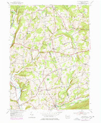
1954 Map of Stillwater
USGS Topo · Published 1978About this map
Fishing Creek and Huntington Creek wind through the borderlands of Columbia and Luzerne counties, defining a landscape of narrow valleys and prominent ridges like Sugarloaf and Tubbs Hill. The settlement pattern reflects an established agricultural and rural community, with small hamlets like Stillwater, Cambra, and New Columbus serving as local hubs. This 1954 edition, with updates from the late 1960s and 1970s, captures the region's enduring character before significant modern development, showing a network of country roads connecting landmarks such as St James Ch and Hamline Ch.
Find a feature on this map
64 named features on this map. Tap any name to fly to it.
Don’t see what you’re looking for? This feature index may not catch every label — zoom into the map to look around manually.
Map Details
Editions of this 1954 Stillwater Map
4 editions found
Other maps of this area

1891 · Harveys Lake
USGS Topo · 1:62,500

1893 · Harvey Lake
USGS Topo · 1:62,500

1894 · Shickshinny
USGS Topo · 1:62,500

1894 · Bloomsburg
USGS Topo · 1:62,500

1934 · Laporte
USGS Topo · 1:62,500

1946 · Shickshinny
USGS Topo · 1:31,680

1946 · Berwick
USGS Topo · 1:31,680

1946 · Sweet Valley
USGS Topo · 1:24,000

1947 · Bloomsburg
USGS Topo · 1:24,000

1947 · Stillwater
USGS Topo · 1:24,000
Featured Places
- New Columbus, PA
- Stillwater, PA
- Fairmount Springs, Fairmount Township
- Honeytown, Fishing Creek Township
- Briar Creek Township, PA