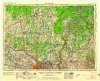
1958 Map of Stillwater
USGS Topo · Published 1958About this map
The St Croix River serves as the central artery and border between Minnesota and Wisconsin in this mid-century survey, dividing a landscape shaped by glacial lakes and river commerce. To the southwest, the urban cores of Minneapolis and St Paul are depicted at a pivotal moment of suburban expansion, with the Twin Cities Arsenal Military Reservation and White Bear Lake marking the northern edge of the metropolitan footprint.
Find a feature on this map
142 named features on this map. Tap any name to fly to it.
Don’t see what you’re looking for? This feature index may not catch every label — zoom into the map to look around manually.
Map Details
Editions of this 1958 Stillwater Map
2 editions found

Other maps of this area

1896 · Minneapolis
USGS Topo · 1:62,500

1896 · St. Paul
USGS Topo · 1:62,500

1900 · St Croix Dalles
USGS Topo · 1:62,500

1901 · Minneapolis
USGS Topo · 1:62,500

1901 · St Croix Dalles
USGS Topo · 1:62,500

1902 · White Bear
USGS Topo · 1:62,500

1902 · Anoka
USGS Topo · 1:62,500

1905 · Minnetonka
USGS Topo · 1:62,500

1907 · Minnetonka
USGS Topo · 1:62,500

1909 · Rockford
USGS Topo · 1:62,500