
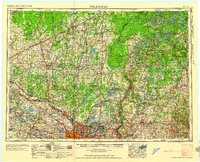
1958 Map of Stillwater
USGS Topo · Published 1958About this map
The Mississippi River and St. Croix River corridors define this regional study, which captures the Upper Midwest in the mid-1950s as the Twin Cities metropolitan area expanded northward. This survey documents the intersection of significant rail networks, including the Great Northern RR, Northern Pacific RR, and Soo Line RR, which supported the agricultural and timber economies of Mille Lacs County and Isanti County. The landscape transitions from the Anoka Sand Plain to the dense lake districts of northwestern Wisconsin.
Find a feature on this map
169 named features on this map. Tap any name to fly to it.
Don’t see what you’re looking for? This feature index may not catch every label — zoom into the map to look around manually.
Map Details
Editions of this 1958 Stillwater Map
2 editions found
Other maps of this area

1896 · Minneapolis
USGS Topo · 1:62,500

1896 · St. Paul
USGS Topo · 1:62,500

1900 · St Croix Dalles
USGS Topo · 1:62,500

1901 · Minneapolis
USGS Topo · 1:62,500

1901 · St Croix Dalles
USGS Topo · 1:62,500

1902 · White Bear
USGS Topo · 1:62,500

1902 · Anoka
USGS Topo · 1:62,500

1905 · Minnetonka
USGS Topo · 1:62,500

1907 · Minnetonka
USGS Topo · 1:62,500

1909 · Rockford
USGS Topo · 1:62,500