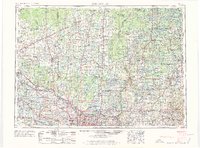
1975 Map of Stillwater
USGS Topo · Published 1975About this map
The St Croix River serves as the central artery for this mid-1970s landscape, defining the state boundary between Minnesota and Wisconsin. Along its banks, historic river towns like Stillwater, Taylors Falls, and St Croix Falls reflect a long-standing reliance on the waterway for transport and industry. The region's transport network is heavily reinforced by significant rail lines, including the Soo Line RR, Burlington Northern RR, and the Milwaukee Road, which connect rural outposts like Grantsburg and Pine City to the metropolitan centers of Minneapolis and St Paul.
Find a feature on this map
337 named features on this map. Tap any name to fly to it.
Don’t see what you’re looking for? This feature index may not catch every label — zoom into the map to look around manually.
Map Details
Editions of this 1975 Stillwater Map
2 editions found

Other maps of this area

1896 · Minneapolis
USGS Topo · 1:62,500

1896 · St. Paul
USGS Topo · 1:62,500

1900 · St Croix Dalles
USGS Topo · 1:62,500

1901 · Minneapolis
USGS Topo · 1:62,500

1901 · St Croix Dalles
USGS Topo · 1:62,500

1902 · White Bear
USGS Topo · 1:62,500

1902 · Anoka
USGS Topo · 1:62,500

1905 · Minnetonka
USGS Topo · 1:62,500

1907 · Minnetonka
USGS Topo · 1:62,500

1909 · Rockford
USGS Topo · 1:62,500