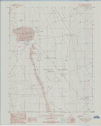
1987 Map of Stinking Spring SW
USGS Topo · Published 1988About this map
Cactus Flat dominates this high-desert basin within the Nellis Air Force Range, revealing a specialized landscape dedicated to Cold War-era military testing. Surveyed in the mid-1980s, the terrain is marked by a complex of technical installations and ballistic markers rather than traditional settlements. Researchers will find precise locations for the Master Launcher and the 9a Gunsite, alongside various tactical points like the Middle Target and several features simply labeled Target. The infrastructure is further defined by a series of Trans Lines and unique maritime-inspired desert markers such as the Main Lake Rad Ref. This topographic record provides a rare look at the spatial organization of restricted government testing grounds, where named landmarks like Tiger and Impact signify the site's primary function during a period of intense military readiness.
Find a feature on this map
13 named features on this map. Tap any name to fly to it.
Don’t see what you’re looking for? This feature index may not catch every label — zoom into the map to look around manually.
Map Details
Editions of this 1987 Stinking Spring SW Map
This is the sole edition of this map. No revisions or reprints were ever made.
Other maps of this area

1908 · Kawich
USGS Topo · 1:250,000

1942 · Cactus Range
USGS Topo · 1:125,000

1952 · Stinking Spring
USGS Topo · 1:62,500

1952 · Mellan
USGS Topo · 1:62,500

1952 · Cactus Spring
USGS Topo · 1:62,500

1952 · Cactus Peak
USGS Topo · 1:62,500

1954 · Goldfield
USGS Topo · 1:250,000

1955 · Goldfield
USGS Topo · 1:250,000

1958 · Goldfield
USGS Topo · 1:250,000

1962 · Goldfield
USGS Topo · 1:250,000