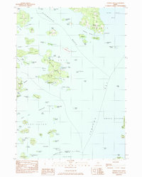
1983 Map of Stinson Neck
USGS Topo · Published 1983About this map
Stinson Neck and the surrounding islands of Hancock County anchor this coastal study, detailing a landscape defined by seafaring traditions and granite geography in the early 1980s. The settlement of Sunshine and the nearby Haystack Mtn Sch of Crafts illustrate the area's transition into a center for artisanal heritage, while Lobster Beds noted along the shoreline point to the enduring maritime economy. The map traces the intricate coastline from Naskeag in the north down to Oceanville on Deer Isle, capturing the countless coves and reaches that served as vital thoroughfares.
Find a feature on this map
111 named features on this map. Tap any name to fly to it.
Don’t see what you’re looking for? This feature index may not catch every label — zoom into the map to look around manually.
Map Details
Editions of this 1983 Stinson Neck Map
This is the sole edition of this map. No revisions or reprints were ever made.
Other maps of this area

1904 · Deer Isle
USGS Topo · 1:62,500

1904 · Mount Desert
USGS Topo · 1:62,500

1904 · Swan Island
USGS Topo · 1:62,500

1904 · Bluehill
USGS Topo · 1:62,500

1905 · Penobscot Bay
USGS Topo · 1:125,000

1942 · Mount Desert
USGS Topo · 1:62,500

1942 · Deer Isle
USGS Topo · 1:62,500

1943 · Swans Island
USGS Topo · 1:62,500

1944 · Blue Hill
USGS Topo · 1:62,500

1944 · Deer Isle
USGS Topo · 1:62,500