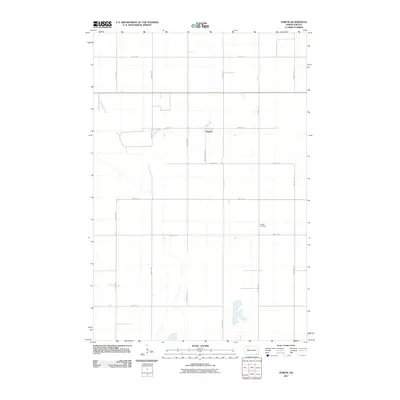
2011 Map of Stirum
USGS Topo · Published 2011About this map
Stirum sits at the center of this Sargent County landscape, characterized by the precise section-line road grid of the North Dakota plains. The settlement is positioned along 83rd St SE, with local streets like Wunderlich St S providing the internal structure for the small community. Away from the central hub, the terrain is defined by its agricultural layout, where arterial routes such as 125th Ave SE and 121st Ave SE stretch across the prairie to connect isolated farmsteads and rural properties. Evidence of the area's earlier history is preserved at Harlem Cemetery, located south of the main townsite near the intersection of 86th St SE. This 2011 survey captures a quiet period in the northern plains, where the land is strictly organized by a network of numbered avenues and streets that reflect a century of homesteading and rural development.
Find a feature on this map
15 named features on this map. Tap any name to fly to it.
Don’t see what you’re looking for? This feature index may not catch every label — zoom into the map to look around manually.
Map Details
Editions of this 2011 Stirum Map
This is the sole edition of this map. No revisions or reprints were ever made.
Other maps of this area

1952 · Crete
USGS Topo · 1:24,000

1953 · Fargo
USGS Topo · 1:250,000

1956 · Fargo
USGS Topo · 1:250,000
1956 · Straubville
USGS Topo · 1:24,000

1957 · Elliott SW
USGS Topo · 1:24,000

1957 · Stirum
USGS Topo · 1:24,000

1957 · Cogswell
USGS Topo · 1:24,000

1957 · Elliott SE
USGS Topo · 1:24,000
1958 · Forman
USGS Topo · 1:24,000

1962 · Lisbon SW
USGS Topo · 1:24,000