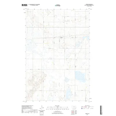
2017 Map of Stirum
USGS Topo · Published 2017About this map
Stirum sits at the heart of this Sargent County landscape, serving as a primary point of reference for the surrounding rural townships. The layout reveals a high concentration of wetlands and water features typical of the region, including the prominent Big Slough to the west. This 2017 survey by the U.S. Geological Survey provides a precise view of the local infrastructure, from the village streets like Wunderlich St S to the regional arteries of Co Rd 1 and Co Rd 4. Genealogists and local historians will find value in the location of Harlem Cem, which remains a vital landmark south of the town center. The map reflects a landscape defined by sectional grid roads that partition the vast prairie and wetland complex.
Find a feature on this map
21 named features on this map. Tap any name to fly to it.
Don’t see what you’re looking for? This feature index may not catch every label — zoom into the map to look around manually.
Map Details
Editions of this 2017 Stirum Map
This is the sole edition of this map. No revisions or reprints were ever made.
Other maps of this area

1952 · Crete
USGS Topo · 1:24,000

1953 · Fargo
USGS Topo · 1:250,000

1956 · Fargo
USGS Topo · 1:250,000
1956 · Straubville
USGS Topo · 1:24,000

1957 · Elliott SW
USGS Topo · 1:24,000

1957 · Stirum
USGS Topo · 1:24,000

1957 · Cogswell
USGS Topo · 1:24,000

1957 · Elliott SE
USGS Topo · 1:24,000
1958 · Forman
USGS Topo · 1:24,000

1962 · Lisbon SW
USGS Topo · 1:24,000