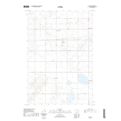
2020 Map of Stirum
USGS Topo · Published 2020About this map
The small settlement of Stirum sits at the heart of this Sargent County landscape, where the flat agricultural plains of North Dakota are defined by a meticulous grid of section lines and township roads. This modern survey illustrates a quiet prairie community organized around landmarks like the Stirum Cem and the nearby Harlem Cem, which serve as significant points of interest for genealogists and local historians tracing the families who settled this region. The natural hydrology is characterized by numerous small wetlands and the prominent Big Slough, which meanders across the central portion of the quadrangle. The township divisions, including t132n r57w and t131n r57w, provide the essential framework for understanding property boundaries and the enduring rural structure of the Great Plains in the early twenty-first century.
Find a feature on this map
22 named features on this map. Tap any name to fly to it.
Don’t see what you’re looking for? This feature index may not catch every label — zoom into the map to look around manually.
Map Details
Editions of this 2020 Stirum Map
This is the sole edition of this map. No revisions or reprints were ever made.
Other maps of this area

1952 · Crete
USGS Topo · 1:24,000

1953 · Fargo
USGS Topo · 1:250,000

1956 · Fargo
USGS Topo · 1:250,000
1956 · Straubville
USGS Topo · 1:24,000

1957 · Elliott SW
USGS Topo · 1:24,000

1957 · Stirum
USGS Topo · 1:24,000

1957 · Cogswell
USGS Topo · 1:24,000

1957 · Elliott SE
USGS Topo · 1:24,000
1958 · Forman
USGS Topo · 1:24,000

1962 · Lisbon SW
USGS Topo · 1:24,000