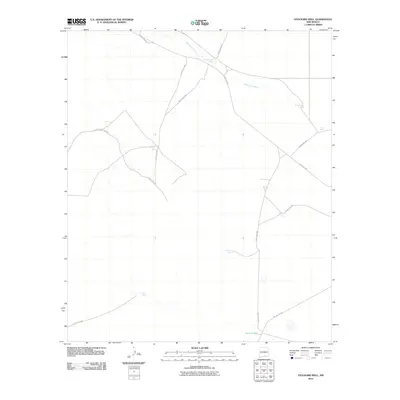
2010 Map of Stockard Well
USGS Topo · Published 2010About this map
Stockard Well anchors this high-desert landscape in Otero County, where water management is the primary driver of development and geography. The intermittent course of the Sacramento River meanders across the northern portion of the quadrangle, flanked by numerous small-scale water features that sustain local ranching operations. These infrastructure points, including Horse Camp Tanks, Rawhide Tank, and Coyote Tank, are connected by a network of county roads such as County Rd-F052 and County Rd-F001. The map reveals a highly functional rangeland economy at the start of the 21st century, where even isolated features like Section Tank or CC Tank serve as critical landmarks for navigation and land use in a region defined by its arid environment and sparse human settlement.
Find a feature on this map
15 named features on this map. Tap any name to fly to it.
Don’t see what you’re looking for? This feature index may not catch every label — zoom into the map to look around manually.
Map Details
Editions of this 2010 Stockard Well Map
This is the sole edition of this map. No revisions or reprints were ever made.
Other maps of this area

1954 · Carlsbad
USGS Topo · 1:250,000

1958 · Carlsbad
USGS Topo · 1:250,000

1959 · Alamo Mountain
USGS Topo · 1:62,500

1963 · Indian Draw
USGS Topo · 1:24,000

1963 · Cleones Tank
USGS Topo · 1:24,000

1970 · Shiloh Hills
USGS Topo · 1:24,000

1975 · Alamo Mountain NE
USGS Topo · 1:24,000
1975 · B T Ranch
USGS Topo · 1:24,000

1979 · Crow Flats
USGS Topo · 1:100,000
1980 · El Paso Draw
USGS Topo · 1:24,000