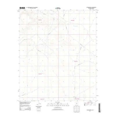
2013 Map of Stockard Well
USGS Topo · Published 2013About this map
Stockard Well anchors the southern portion of this landscape, situated near a sparse network of county roads in the high desert of Otero County. The ephemeral course of the Sacramento River carves through the northern terrain, indicating a drainage system that defines the local topography. This 2013 survey illustrates a region largely defined by its vast open spaces and infrastructure geared toward land management and ranching. A grid of designated routes including Co Road F047, Co Road F052, and Co Road F036 provides the primary access through the townships, tracing the natural contours of the basin. The map serves as a record of rural Otero County before more recent developments, highlighting isolated landmarks and the essential water-access point at the namesake well.
Find a feature on this map
16 named features on this map. Tap any name to fly to it.
Don’t see what you’re looking for? This feature index may not catch every label — zoom into the map to look around manually.
Map Details
Editions of this 2013 Stockard Well Map
This is the sole edition of this map. No revisions or reprints were ever made.
Other maps of this area

1954 · Carlsbad
USGS Topo · 1:250,000

1958 · Carlsbad
USGS Topo · 1:250,000

1959 · Alamo Mountain
USGS Topo · 1:62,500

1963 · Indian Draw
USGS Topo · 1:24,000

1963 · Cleones Tank
USGS Topo · 1:24,000

1970 · Shiloh Hills
USGS Topo · 1:24,000

1975 · Alamo Mountain NE
USGS Topo · 1:24,000
1975 · B T Ranch
USGS Topo · 1:24,000

1979 · Crow Flats
USGS Topo · 1:100,000
1980 · El Paso Draw
USGS Topo · 1:24,000