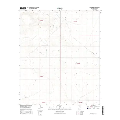
2017 Map of Stockard Well
USGS Topo · Published 2017About this map
The Sacramento River flows through the northern reaches of this high-altitude landscape in Otero County, marking the primary drainage in an otherwise arid expanse. The terrain is defined by a dense network of ridges and canyons, where the elevation changes are documented by the U.S. Geological Survey with twenty-foot contour intervals. Settlement is nearly non-existent, centered almost entirely on the namesake Stockard Well located in the southern portion of the quadrangle.
Find a feature on this map
16 named features on this map. Tap any name to fly to it.
Don’t see what you’re looking for? This feature index may not catch every label — zoom into the map to look around manually.
Map Details
Editions of this 2017 Stockard Well Map
This is the sole edition of this map. No revisions or reprints were ever made.
Other maps of this area

1954 · Carlsbad
USGS Topo · 1:250,000

1958 · Carlsbad
USGS Topo · 1:250,000

1959 · Alamo Mountain
USGS Topo · 1:62,500

1963 · Indian Draw
USGS Topo · 1:24,000

1963 · Cleones Tank
USGS Topo · 1:24,000

1970 · Shiloh Hills
USGS Topo · 1:24,000

1975 · Alamo Mountain NE
USGS Topo · 1:24,000
1975 · B T Ranch
USGS Topo · 1:24,000

1979 · Crow Flats
USGS Topo · 1:100,000
1980 · El Paso Draw
USGS Topo · 1:24,000