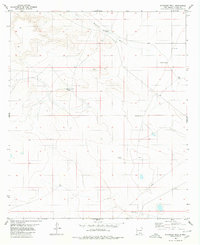
1980 Map of Stockard Well
USGS Topo · Published 1980About this map
The Sacramento River carves a path through this corner of Otero County, defining a landscape dominated by livestock and water management infrastructure in the mid-1970s. The map reveals an intricate network of named water sources essential for desert ranching, such as Horse Camp Tanks and Rawhide Tank. These features, along with Center Well and Partnership Well, suggest a collaborative approach to land use among local ranchers.
Find a feature on this map
14 named features on this map. Tap any name to fly to it.
Don’t see what you’re looking for? This feature index may not catch every label — zoom into the map to look around manually.
Map Details
Editions of this 1980 Stockard Well Map
This is the sole edition of this map. No revisions or reprints were ever made.
Other maps of this area

1954 · Carlsbad
USGS Topo · 1:250,000

1958 · Carlsbad
USGS Topo · 1:250,000

1959 · Alamo Mountain
USGS Topo · 1:62,500

1963 · Indian Draw
USGS Topo · 1:24,000

1963 · Cleones Tank
USGS Topo · 1:24,000

1970 · Shiloh Hills
USGS Topo · 1:24,000

1975 · Alamo Mountain NE
USGS Topo · 1:24,000
1975 · B T Ranch
USGS Topo · 1:24,000

1979 · Crow Flats
USGS Topo · 1:100,000
1980 · El Paso Draw
USGS Topo · 1:24,000