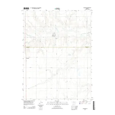
2014 Map of Stockham
USGS Topo · Published 2014About this map
Stockham anchors the northern portion of this agricultural landscape along the Hamilton Co and Clay Co line. The settlement is defined by a traditional grid of streets, including Main St and Scott St, which served as a local hub for the surrounding farmsteads. To the south, the village of Eldorado sits along the western edge, near the intersection of Brown St and Ne-14. The terrain is shaped by the meandering path of the W Fork Big Blue River and its various tributaries, such as the N Br W Fork Big Blue River. These waterways, along with the Thieszen Reservoir and Nuss Reservoir, provide the primary relief in an otherwise flat, section-lined expanse. Genealogists will find the Stockham Cem located just south of the main village, a key landmark for tracing early families in this part of Nebraska.
Find a feature on this map
38 named features on this map. Tap any name to fly to it.
Don’t see what you’re looking for? This feature index may not catch every label — zoom into the map to look around manually.
Map Details
Editions of this 2014 Stockham Map
This is the sole edition of this map. No revisions or reprints were ever made.
Other maps of this area

1898 · York
USGS Topo · 1:125,000

1898 · Grand Island
USGS Topo · 1:125,000

1899 · York
USGS Topo · 1:125,000

1955 · Lincoln
USGS Topo · 1:250,000

1955 · Grand Island
USGS Topo · 1:250,000

1957 · Lincoln
USGS Topo · 1:250,000

1957 · Grand Island
USGS Topo · 1:250,000

1958 · Grand Island
USGS Topo · 1:250,000

1958 · Lincoln
USGS Topo · 1:250,000
1968 · Aurora West
USGS Topo · 1:24,000