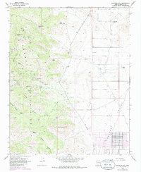
1968 Map of Stockton Hill
USGS Topo · Published 1985About this map
Mining operations dominate the slopes of the Cerbat Mountains, where a dense network of claims and tunnels follows the mineral-rich geology of western Arizona. The small settlement of Stockton serves as a central point for the surrounding industry, which includes the Stockton Mine, Prince George Mine, and Jordan Mine. This era of extraction is visible through the numerous labeled prospects like the C O D Mine and the Summit Mine that pockmark the terrain between Cerbat Canyon and Charcoal Canyon. Below the peaks, the landscape shifts abruptly into the wide expanse of the Hualapai Valley. In the lower elevations, water sources were critical for both mining and ranching, evidenced by Canyon Station Spring, Gaddis Spring, and Blue Rock Tank. The presence of the Aqueduct and Pipeline running near the Stockton Hill Road highlights the infrastructure required to support this arid environment during the late 1960s.
Find a feature on this map
48 named features on this map. Tap any name to fly to it.
Don’t see what you’re looking for? This feature index may not catch every label — zoom into the map to look around manually.
Map Details
Editions of this 1968 Stockton Hill Map
4 editions found
Other maps of this area

1886 · Diamond Creek
USGS Topo · 1:250,000

1886 · Camp Mohave
USGS Topo · 1:250,000

1892 · Diamond Creek
USGS Topo · 1:250,000

1892 · Camp Mohave
USGS Topo · 1:250,000

1939 · Chloride
USGS Topo · 1:48,000

1942 · Camp Mohave
USGS Topo · 1:250,000

1944 · Chloride
USGS Topo · 1:62,500

1947 · Kingman
USGS Topo · 1:250,000

1948 · Kingman
USGS Topo · 1:250,000

1948 · Williams
USGS Topo · 1:250,000