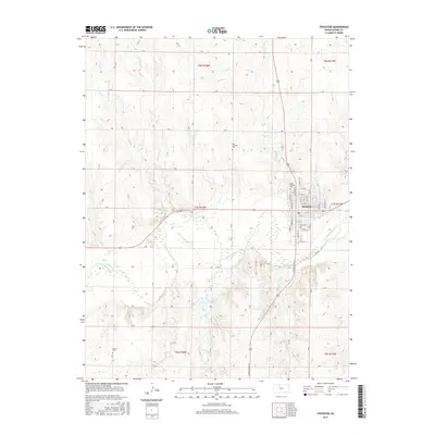
2015 Map of Stockton
USGS Topo · Published 2015About this map
Stockton serves as the focal point of this Rooks County landscape, situated where the S Fork Solomon River winds through the central plains. The town's grid is meticulously detailed, extending from N Walnut St down to S 11th St, illustrating the community's established footprint. To the south, Lake Stockton and the surrounding drainage of Boxelder Cr and Roberts Roost Cr reveal a terrain defined by water management and natural runoff patterns. For those tracing local heritage, several significant burial sites are documented across the rural township lines, including Old Stockton Cem, Saint Thomas Cem, and Hobart Cem. The surrounding sections are partitioned by a systematic network of section roads like F Rd and M Rd, while smaller tributaries such as Dibble Cr and Cocklebur Cr carve through the agricultural uplands north of the river valley.
Find a feature on this map
52 named features on this map. Tap any name to fly to it.
Don’t see what you’re looking for? This feature index may not catch every label — zoom into the map to look around manually.
Map Details
Editions of this 2015 Stockton Map
This is the sole edition of this map. No revisions or reprints were ever made.
Other maps of this area

1893 · Phillipsburg
USGS Topo · 1:125,000

1896 · Plainville
USGS Topo · 1:125,000

1952 · Webster Dam
USGS Topo · 1:24,000

1953 · Woodston NW
USGS Topo · 1:24,000

1953 · Stockton
USGS Topo · 1:24,000

1955 · Beloit
USGS Topo · 1:250,000

1959 · Beloit
USGS Topo · 1:250,000

1961 · Kirwin SW
USGS Topo · 1:24,000

1969 · Stockton SW
USGS Topo · 1:24,000

1972 · Glade SW
USGS Topo · 1:24,000