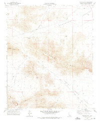
1970 Map of Stoddard Well
USGS Topo · Published 1975About this map
Stoddard Well and the surrounding high desert of San Bernardino County are defined by a history of resource extraction and transit in this 1970 survey. The landscape is dominated by the massive Stoddard Ridge and the steep slopes of Stoddard Mountain, where a network of primitive routes like Stoddard Well Road and various unnamed Jeep Trails provide access to remote mining operations. Industrial activity is concentrated near the base of Sidewinder Mountain, where the Sidewinder Mine, a Quarry, and an associated Conveyor suggest a period of active quarrying and mineral recovery. To the north, the terrain transitions into the Stoddard Valley, marked by essential water sources like Dry Well and an aviation-related Landing Strip, illustrating the infrastructure required for survival and industry in this arid environment.
Find a feature on this map
24 named features on this map. Tap any name to fly to it.
Don’t see what you’re looking for? This feature index may not catch every label — zoom into the map to look around manually.
Map Details
Editions of this 1970 Stoddard Well Map
2 editions found
Other maps of this area

1932 · Barstow
USGS Topo · 1:125,000

1934 · Barstow
USGS Topo · 1:125,000

1953 · San Bernardino
USGS Topo · 1:250,000

1955 · Ord Mountains
USGS Topo · 1:62,500

1956 · San Bernardino
USGS Topo · 1:250,000

1956 · Daggett
USGS Topo · 1:62,500

1956 · Barstow
USGS Topo · 1:62,500

1957 · Apple Valley
USGS Topo · 1:62,500

1957 · San Bernardino
USGS Topo · 1:250,000

1958 · San Bernardino
USGS Topo · 1:250,000