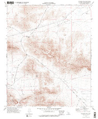
1970 Map of Stoddard Well
USGS Topo · Published 1975About this map
Stoddard Well serves as the focal point for this Mojave Desert survey, positioned at the convergence of Stoddard Well Road and Boulder Road. The landscape is defined by the high elevations of Stoddard Mountain and Stoddard Ridge, where a network of trails and unimproved roads connects scattered mining operations. Evidence of the region's mineral extraction economy is prominent, with several unnamed Mines and a Quarry dotting the slopes, alongside the established Forty Mine and Sidewinder Mine located further south near Sidewinder Mountain.
Find a feature on this map
19 named features on this map. Tap any name to fly to it.
Don’t see what you’re looking for? This feature index may not catch every label — zoom into the map to look around manually.
Map Details
Editions of this 1970 Stoddard Well Map
2 editions found
Other maps of this area

1932 · Barstow
USGS Topo · 1:125,000

1934 · Barstow
USGS Topo · 1:125,000

1953 · San Bernardino
USGS Topo · 1:250,000

1955 · Ord Mountains
USGS Topo · 1:62,500

1956 · San Bernardino
USGS Topo · 1:250,000

1956 · Daggett
USGS Topo · 1:62,500

1956 · Barstow
USGS Topo · 1:62,500

1957 · Apple Valley
USGS Topo · 1:62,500

1957 · San Bernardino
USGS Topo · 1:250,000

1958 · San Bernardino
USGS Topo · 1:250,000