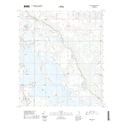
2021 Map of Stokes Ferry
USGS Topo · Published 2021About this map
The Withlacoochee River carves a winding path through the heart of the Florida wetlands, defining the borders of Citrus, Marion, and Sumter counties. This aquatic landscape is dominated by the intricate reaches of Tsala Apopka Lake and the Potts Preserve Trl, where dry land is often isolated into named landforms such as Spooner Island, Gilchrist Island, and the aptly named Point Lonesome. The topography reveals a mosaic of marshes and hammocks, including a distinctive bend in the river known as The Pocket. Settlement patterns are concentrated near the historical crossing at Stokes Ferry and the recreational areas around Hernando Beach and Community Park. The area also serves local aviation through the Twelve Oaks Airport and Drake Ranch Airport, highlighting a transition from traditional river-and-wetland navigation to modern accessibility within this complex riverine environment.
Find a feature on this map
111 named features on this map. Tap any name to fly to it.
Don’t see what you’re looking for? This feature index may not catch every label — zoom into the map to look around manually.
Map Details
Editions of this 2021 Stokes Ferry Map
This is the sole edition of this map. No revisions or reprints were ever made.
Other maps of this area

1892 · Dunnellon
USGS Topo · 1:62,500

1893 · Panasoffkee
USGS Topo · 1:62,500

1894 · Dunnellon
USGS Topo · 1:62,500

1895 · Tsala Apopka
USGS Topo · 1:62,500

1895 · Panasoffkee
USGS Topo · 1:62,500

1895 · Ocala
USGS Topo · 1:62,500

1954 · Lecanto
USGS Topo · 1:24,000

1954 · Holder
USGS Topo · 1:24,000

1954 · Tsala Apopka NE
USGS Topo · 1:24,000

1954 · Dunnellon
USGS Topo · 1:24,000