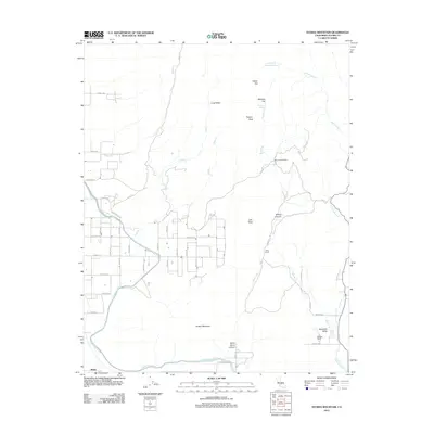
2012 Map of Stokes Mountain
USGS Topo · Published 2012About this map
Stokes Mountain dominates this portion of Tulare County, where the transition from the Sierra Nevada foothills to the agricultural basin is clearly defined by the Friant-Kern Canal. This vital water infrastructure snakes across the southern and western landscape, fueling the orchards and fields of Woodlake Valley. The map reveals a land divided between the geometric grid of agricultural roads like Road 152 and the winding canyons of the high ground. Established local holdings such as Moore Creek Ranch, Dixie Ranch, and Jackson Ranch are situated among the peaks and valleys, including Long Valley and Wilcox Canyon. From the heights of Sawyer Peak and Cliff Peak down to the settlement of Wimp, the map documents a working landscape defined by its water sources, from the modern canal to seasonal flows like Cottonwood Creek and Rattlesnake Creek.
Find a feature on this map
53 named features on this map. Tap any name to fly to it.
Don’t see what you’re looking for? This feature index may not catch every label — zoom into the map to look around manually.
Map Details
Editions of this 2012 Stokes Mountain Map
This is the sole edition of this map. No revisions or reprints were ever made.
Other maps of this area

1921 · Squaw Valley
USGS Topo · 1:31,680

1921 · Stokes Mountain
USGS Topo · 1:24,000

1922 · Trimmer
USGS Topo · 1:96,000

1923 · Sultana
USGS Topo · 1:31,680

1924 · Citrus Cove
USGS Topo · 1:31,680

1924 · Dinuba
USGS Topo · 1:125,000

1924 · Stokes Mountain
USGS Topo · 1:31,680

1926 · Ivanhoe
USGS Topo · 1:31,680

1927 · Monson
USGS Topo · 1:31,680

1928 · Lemon Cove
USGS Topo · 1:31,680