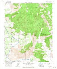
1966 Map of Stokes Mtn.
USGS Topo · Published 1968About this map
Stokes Mountain and Sawyer Peak dominate the topography of this Tulare County landscape, where the Sierra Nevada foothills meet the agricultural valley floor. The mid-1960s landscape shows a clear transition from the high, drainage-carved terrain of Stone Corral Canyon and Long Valley Creek to the engineered water systems below. The massive Friant Kern Canal cuts across the southwestern quadrant, a critical piece of Central Valley infrastructure that transformed the local economy. Scattered throughout the hills are several named holdings, including Moore Creek Ranch and Dixie Ranch, alongside legacy tracks like the A T & S F railroad. Geologic activity is noted by several Quarry sites and a network of fire roads and jeep trails, such as Buttonwillow Road and Sontag Road, which provide access to the various springs and flats tucked between the peaks.
Find a feature on this map
34 named features on this map. Tap any name to fly to it.
Don’t see what you’re looking for? This feature index may not catch every label — zoom into the map to look around manually.
Map Details
Editions of this 1966 Stokes Mtn. Map
This is the sole edition of this map. No revisions or reprints were ever made.
Other maps of this area

1921 · Squaw Valley
USGS Topo · 1:31,680

1921 · Stokes Mountain
USGS Topo · 1:24,000

1922 · Trimmer
USGS Topo · 1:96,000

1923 · Sultana
USGS Topo · 1:31,680

1924 · Citrus Cove
USGS Topo · 1:31,680

1924 · Dinuba
USGS Topo · 1:125,000

1924 · Stokes Mountain
USGS Topo · 1:31,680

1926 · Ivanhoe
USGS Topo · 1:31,680

1927 · Monson
USGS Topo · 1:31,680

1928 · Lemon Cove
USGS Topo · 1:31,680