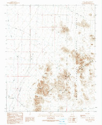
1990 Map of Stone Cabin
USGS Topo · Published 1990About this map
Stone Cabin stands as a lonely outpost at the intersection of King Road and an unimproved desert track in this 1990 survey of Yuma County. This arid landscape is dominated by the steep, jagged reaches of the Castle Dome Mountains and the sprawling protected lands of the Kofa National Wildlife Refuge. The map reveals a world where survival depends on seasonal water sources and specific geological features, from the Hidden Valley Tanks to a distinctive Natural Arch found among the peaks.
Find a feature on this map
18 named features on this map. Tap any name to fly to it.
Don’t see what you’re looking for? This feature index may not catch every label — zoom into the map to look around manually.
Map Details
Editions of this 1990 Stone Cabin Map
This is the sole edition of this map. No revisions or reprints were ever made.
Other maps of this area

1934 · Trigo Peaks
USGS Topo · 1:48,000

1939 · Red Hill
USGS Topo · 1:62,500

1939 · Trigo Peaks
USGS Topo · 1:62,500

1942 · Blythe
USGS Topo · 1:250,000

1954 · Salton Sea
USGS Topo · 1:250,000

1954 · Red Hill
USGS Topo · 1:62,500

1954 · Trigo Peaks
USGS Topo · 1:62,500

1955 · Salton Sea
USGS Topo · 1:250,000

1959 · Salton Sea
USGS Topo · 1:250,000
1962 · Livingston Hills
USGS Topo · 1:62,500