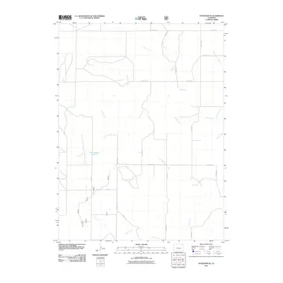
2011 Map of Stoneham NE
USGS Topo · Published 2011About this map
East Stoneham Reservoir sits at the heart of this high plains landscape, anchoring an intricate network of seasonal watercourses and rural corridors. The drainage patterns of Pawnee Creek and its associated Pawnee Inlet Number 2 dominate the central terrain, reflecting the vital role of water management in this arid section of Weld County. To the south, Raymer Creek cuts through the landscape, while Spring Creek and Cottonwood Creek define the northern reaches.
Find a feature on this map
17 named features on this map. Tap any name to fly to it.
Don’t see what you’re looking for? This feature index may not catch every label — zoom into the map to look around manually.
Map Details
Editions of this 2011 Stoneham NE Map
This is the sole edition of this map. No revisions or reprints were ever made.
Other maps of this area

1951 · Willard
USGS Topo · 1:24,000

1951 · Wild Horse Lake
USGS Topo · 1:24,000

1954 · Sterling
USGS Topo · 1:250,000

1958 · Sterling
USGS Topo · 1:250,000

1977 · Stoneham
USGS Topo · 1:24,000

1977 · Stoneham NE
USGS Topo · 1:24,000

1977 · Avalo SE
USGS Topo · 1:24,000

1978 · Stoneham NW
USGS Topo · 1:24,000
1978 · Avalo
USGS Topo · 1:24,000
1978 · Stoneham SE
USGS Topo · 1:24,000