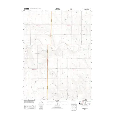
2013 Map of Stoneham NE
USGS Topo · Published 2013About this map
The Pawnee National Grassland dominates this high-plains landscape on the border of Weld and Logan Counties. This 2013 survey reveals a largely open territory defined by an intricate network of drainage systems, including the westward-flowing Cottonwood Creek and the meandering path of Raymer Creek in the south. The topography is shaped by the Pawnee Valley, where the land drops away from the surrounding plateaus.
Find a feature on this map
30 named features on this map. Tap any name to fly to it.
Don’t see what you’re looking for? This feature index may not catch every label — zoom into the map to look around manually.
Map Details
Editions of this 2013 Stoneham NE Map
This is the sole edition of this map. No revisions or reprints were ever made.
Other maps of this area

1951 · Willard
USGS Topo · 1:24,000

1951 · Wild Horse Lake
USGS Topo · 1:24,000

1954 · Sterling
USGS Topo · 1:250,000

1958 · Sterling
USGS Topo · 1:250,000

1977 · Stoneham
USGS Topo · 1:24,000

1977 · Stoneham NE
USGS Topo · 1:24,000

1977 · Avalo SE
USGS Topo · 1:24,000

1978 · Stoneham NW
USGS Topo · 1:24,000
1978 · Avalo
USGS Topo · 1:24,000
1978 · Stoneham SE
USGS Topo · 1:24,000