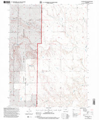
1997 Map of Stoneham NE
USGS Topo · Published 2000About this map
Pawnee National Grassland dominates this high plains landscape along the Weld Co Logan Co boundary, where an intricate network of seasonal drainages and water management infrastructure defines the terrain. The hydrological character of the area is centered on Pawnee Creek and its associated features, such as Pawnee Inlet No 2 and the East Stoneham Reservoir. These features, alongside Cottonwood Creek and Spring Creek, trace the natural flow of water across a region that relies heavily on irrigation and storage.
Find a feature on this map
13 named features on this map. Tap any name to fly to it.
Don’t see what you’re looking for? This feature index may not catch every label — zoom into the map to look around manually.
Map Details
Editions of this 1997 Stoneham NE Map
This is the sole edition of this map. No revisions or reprints were ever made.
Other maps of this area

1951 · Willard
USGS Topo · 1:24,000

1951 · Wild Horse Lake
USGS Topo · 1:24,000

1954 · Sterling
USGS Topo · 1:250,000

1958 · Sterling
USGS Topo · 1:250,000

1977 · Stoneham
USGS Topo · 1:24,000

1977 · Stoneham NE
USGS Topo · 1:24,000

1977 · Avalo SE
USGS Topo · 1:24,000

1978 · Stoneham NW
USGS Topo · 1:24,000
1978 · Avalo
USGS Topo · 1:24,000
1978 · Stoneham SE
USGS Topo · 1:24,000