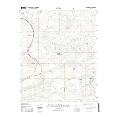
2014 Map of Stoneman Lake
USGS Topo · Published 2014About this map
Coconino National Forest defines the high-country landscape of this 2014 survey, where the border between Coconino and Yavapai counties crosses a complex system of volcanic landforms and canyons. The terrain is marked by prominent elevations like Luke Mtn, Fain Mtn, and Lee Butte, which overlook a network of seasonal water catchments and historical ranching improvements. Named features such as Bar M Canyon, Six Canyon, and Cedar Tank Canyon carve through the plateau, reflecting the importance of drainage and water management in this arid region.
Find a feature on this map
79 named features on this map. Tap any name to fly to it.
Don’t see what you’re looking for? This feature index may not catch every label — zoom into the map to look around manually.
Map Details
Editions of this 2014 Stoneman Lake Map
This is the sole edition of this map. No revisions or reprints were ever made.
Other maps of this area

1887 · Verde
USGS Topo · 1:250,000

1892 · Verde
USGS Topo · 1:250,000

1923 · Camp Verde
USGS Topo · 1:125,000

1932 · Camp Verde
USGS Topo · 1:125,000

1936 · Camp Verde
USGS Topo · 1:125,000

1954 · Holbrook
USGS Topo · 1:250,000

1957 · Holbrook
USGS Topo · 1:250,000

1958 · Holbrook
USGS Topo · 1:250,000

1960 · Holbrook
USGS Topo · 1:250,000
1965 · Hutch Mtn.
USGS Topo · 1:24,000