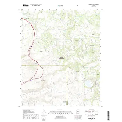
2018 Map of Stoneman Lake
USGS Topo · Published 2018About this map
Stoneman Lake serves as a central focal point for this section of the Coconino National Forest, where the high desert meets the volcanic landscape of northern Arizona. The terrain is marked by a high density of water management features, including dozens of stock tanks such as Basco Tank, Oak Grove Tank, and Wier-Number Eight Tank, which support the region's ranching heritage. Prominent volcanic and erosional landmarks like Lee Butte and Luke Mtn rise above deep drainage systems such as Cedar Tank Canyon and Rarick Canyon. The presence of numerous named springs, including Bristow Spring and Rock Top Spring, alongside the many tanks, reveals a landscape carefully mapped for its vital water sources. Access is primarily defined by the historic routes of Rocky Park Rd and Stoneman Lake Rd, which navigate the complex topography near the Yavapai and Coconino county lines.
Find a feature on this map
67 named features on this map. Tap any name to fly to it.
Don’t see what you’re looking for? This feature index may not catch every label — zoom into the map to look around manually.
Map Details
Editions of this 2018 Stoneman Lake Map
This is the sole edition of this map. No revisions or reprints were ever made.
Other maps of this area

1887 · Verde
USGS Topo · 1:250,000

1892 · Verde
USGS Topo · 1:250,000

1923 · Camp Verde
USGS Topo · 1:125,000

1932 · Camp Verde
USGS Topo · 1:125,000

1936 · Camp Verde
USGS Topo · 1:125,000

1954 · Holbrook
USGS Topo · 1:250,000

1957 · Holbrook
USGS Topo · 1:250,000

1958 · Holbrook
USGS Topo · 1:250,000

1960 · Holbrook
USGS Topo · 1:250,000
1965 · Hutch Mtn.
USGS Topo · 1:24,000