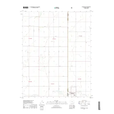
2019 Map of Stonington SE
USGS Topo · Published 2019About this map
The high plains of the Colorado Kansas border define this landscape, where the Baca Co Morton Co line splits a vast expanse of agricultural sections and grasslands. The southern reach of the map is dominated by the Cimarron National Grassland, specifically encompassing Pasture Number Three. Hydrology in this arid region is marked by the seasonal path of the Sand Arroyo Cr in the northwest and the winding course of the N Fork Cimarron River as it crosses the state line. A rigid network of section-line roads, including Co Rd 88 and Co Rd 57, facilitates movement across the township and range divisions. The absence of concentrated settlements highlights the open-range and large-scale ranching character of the territory near the turn of the twenty-first century.
Find a feature on this map
31 named features on this map. Tap any name to fly to it.
Don’t see what you’re looking for? This feature index may not catch every label — zoom into the map to look around manually.
Map Details
Editions of this 2019 Stonington SE Map
This is the sole edition of this map. No revisions or reprints were ever made.
Other maps of this area

1892 · Vilas
USGS Topo · 1:125,000

1955 · La Junta
USGS Topo · 1:250,000

1955 · Dodge City
USGS Topo · 1:250,000

1958 · La Junta
USGS Topo · 1:250,000

1958 · Dodge City
USGS Topo · 1:250,000

1959 · Dodge City
USGS Topo · 1:250,000

1968 · La Junta
USGS Topo · 1:250,000

1973 · Richfield NW
USGS Topo · 1:24,000
1973 · Richfield SW
USGS Topo · 1:24,000
1973 · Elkhart NW
USGS Topo · 1:24,000