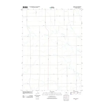
2012 Map of Storla SW
USGS Topo · Published 2012About this map
The waters of W Br Firesteel Cr wind through this rural landscape in Aurora County, creating a meandering drainage pattern across the central and northern sections of the map. This portion of South Dakota is defined by the rigid precision of the Public Land Survey System, with a nearly perfect grid of section-line roads such as 387th Ave and 246th St providing access to the vast agricultural holdings. The map shows the convergence of several small tributaries into Firesteel Cr at the eastern edge. While the terrain lacks concentrated town centers, the intricate network of local routes like 391st Ave and 243rd St illustrates the density of rural settlement and farmstead access at the start of the 2010s.
Find a feature on this map
16 named features on this map. Tap any name to fly to it.
Don’t see what you’re looking for? This feature index may not catch every label — zoom into the map to look around manually.
Map Details
Editions of this 2012 Storla SW Map
This is the sole edition of this map. No revisions or reprints were ever made.
Other maps of this area

1899 · Mitchell
USGS Topo · 1:125,000

1942 · Crow Lake
USGS Topo · 1:62,500

1955 · Mitchell
USGS Topo · 1:250,000

1959 · Mitchell
USGS Topo · 1:250,000
1979 · Fraser Dam
USGS Topo · 1:24,000

1979 · Crystal Lake
USGS Topo · 1:24,000

1979 · Storla SW
USGS Topo · 1:24,000

1979 · Storla
USGS Topo · 1:24,000
1979 · Twin Lakes
USGS Topo · 1:24,000

1980 · Mount Vernon
USGS Topo · 1:24,000
Featured Places
- Hopper Township, SD
- Belford Township, SD
- Firesteel Township, SD
- Palatine Township, SD
- Plankinton Township, SD