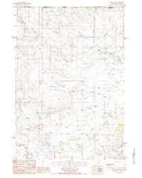
1984 Map of Storm Draw
USGS Topo · Published 1985About this map
The Little Missouri River snakes through the southeastern portion of this map, marked by several levee structures that suggest local efforts to manage the river's flow through the drainage basin. This area, straddling the Montana Wyoming border where Carter and Crook Counties meet, shows a landscape defined by an intricate network of ephemeral watercourses. Prominent drainages like Storm Draw, Cottonwood Draw, and School Section Draw reveal the erosional patterns of this high plains territory. Industrial activity is concentrated in the southern sections, where several Bentonite Pits appear near the North Fork Little Missouri R. These industrial markings, along with the numerous named creeks such as North Thompson Creek and Prickly Pear Creek, illustrate the intersection of natural hydrology and 20th-century resource extraction in the region.
Find a feature on this map
17 named features on this map. Tap any name to fly to it.
Don’t see what you’re looking for? This feature index may not catch every label — zoom into the map to look around manually.
Map Details
Editions of this 1984 Storm Draw Map
This is the sole edition of this map. No revisions or reprints were ever made.
Other maps of this area

1905 · Devils Tower
USGS Topo · 1:125,000

1954 · Strawberry Hill
USGS Topo · 1:24,000

1954 · Ekalaka
USGS Topo · 1:250,000

1954 · Gillette
USGS Topo · 1:250,000

1955 · Gillette
USGS Topo · 1:250,000

1956 · Ekalaka
USGS Topo · 1:250,000

1957 · Seely
USGS Topo · 1:62,500

1957 · Cedar Ridge
USGS Topo · 1:62,500

1958 · Gillette
USGS Topo · 1:250,000

1958 · Ekalaka
USGS Topo · 1:250,000