2001 Map of Storm King Peak
USGS Topo · Published 2005About this map
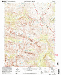
Storm King Peak and the high summits of the Weminuche Wilderness define this high-altitude landscape in the San Juan Mountains. The terrain is characterized by a series of dramatic alpine peaks including Vestal Peak, White Dome, and the Trinity Peaks, which dominate the central and southern portions of the sheet. The Continental Divide snakes through the northeast, separating the headwaters of the Rio Grande from the Vallecito Creek drainage system. Scattered throughout the higher elevations are evidence of historic prospecting, with several Mine and Prospect sites located near Kite Lake and the Beartown (Site) area. This 2001 revision illustrates the topographical complexity of the San Juan National Forest and Rio Grande National Forest before modern climate shifts significantly altered the high-country snowpack and glacier points, such as those found near Sunlight Lake.
Find a feature on this map
75 named features on this map. Tap any name to fly to it.
Don’t see what you’re looking for? This feature index may not catch every label — zoom into the map to look around manually.
Map Details
Editions of this 2001 Storm King Peak Map
This is the sole edition of this map. No revisions or reprints were ever made.
Other maps of this area

1897 · Silverton
USGS Topo · 1:62,500

1900 · Needle Mountains
USGS Topo · 1:62,500

1901 · Silverton
USGS Topo · 1:62,500

1902 · Needle Mountains
USGS Topo · 1:62,500

1902 · Silverton
USGS Topo · 1:62,500

1905 · San Cristobal
USGS Topo · 1:125,000

1907 · San Cristobal
USGS Topo · 1:125,000

1945 · Durango
USGS Topo · 1:250,000

1953 · Durango
USGS Topo · 1:250,000

1954 · Durango
USGS Topo · 1:250,000