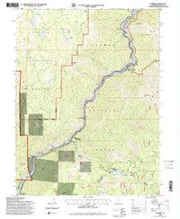
1994 Map of Storrie
USGS Topo · Published 1998About this map
The North Fork Feather River carves a deep path through the Plumas and Lassen National Forests, defining the industrial and transportation character of this mountain region. The Union Pacific railroad and Highway 70 follow the river's tight curves, linking a series of small riverside settlements including Storrie, Tobin, and Rodgers Flat. This 1994 revision captures a landscape dedicated to hydroelectric power generation, evidenced by the Bucks Creek Powerhouse, Rock Creek Powerhouse, and Grizzly Powerhouse situated along the water's edge. High above the river canyon, the Pacific Crest National Scenic Trail traverses the Bucks Lake Wilderness, passing through a high-elevation terrain of named flats and glacial lakes like Campbell Lake and Oliver Lake. The presence of the Indian Bar Sch near Belden points to the established community life that persisted despite the steep, challenging geography of the Feather River canyon.
Find a feature on this map
52 named features on this map. Tap any name to fly to it.
Don’t see what you’re looking for? This feature index may not catch every label — zoom into the map to look around manually.
Map Details
Editions of this 1994 Storrie Map
2 editions found
Other maps of this area

1886 · Lassen Peak
USGS Topo · 1:250,000

1888 · Bidwell Bar
USGS Topo · 1:125,000

1891 · Bidwell Bar
USGS Topo · 1:125,000

1892 · Lassen Peak
USGS Topo · 1:250,000

1893 · Bidwell Bar
USGS Topo · 1:125,000

1894 · Lassen Peak
USGS Topo · 1:250,000

1895 · Bidwell Bar
USGS Topo · 1:125,000

1897 · Bidwell Bar
USGS Topo · 1:125,000

1950 · Bucks Lake
USGS Topo · 1:62,500

1955 · Almanor
USGS Topo · 1:62,500