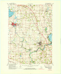
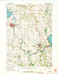
1961 Map of Stoughton
USGS Topo · Published 1980About this map
The Yahara River winds through this 1961 landscape, connecting the expansive waters of Lake Kegonsa and the upper reaches of Lake Koshkonong. This region of southern Wisconsin is defined by its glacial hydrology and the development of early rail corridors, notably the Chicago and North Western and the Milwaukee St Paul and Pacific railroads. The settlement of Stoughton serves as a primary hub, while smaller communities like Cooksville, Edgerton, and Indianford sit along the riverbanks.
Find a feature on this map
94 named features on this map. Tap any name to fly to it.
Don’t see what you’re looking for? This feature index may not catch every label — zoom into the map to look around manually.
Map Details
Editions of this 1961 Stoughton Map
2 editions found
Other maps of this area

1889 · Evansville
USGS Topo · 1:62,500

1890 · Madison
USGS Topo · 1:62,500

1890 · Sun Prairie
USGS Topo · 1:62,500

1890 · Stoughton
USGS Topo · 1:62,500

1891 · Waterloo
USGS Topo · 1:62,500

1891 · Koshkonong
USGS Topo · 1:62,500

1891 · Janesville
USGS Topo · 1:62,500

1892 · Madison
USGS Topo · 1:62,500

1893 · Janesville
USGS Topo · 1:62,500

1893 · Brodhead
USGS Topo · 1:62,500